 DISTANCE: 68.5 miles
AVERAGE SPEED: 11.1 mph
ELEVATION: 2000 feet to 3800 feet to 2100 feet to 4200 feet to 3100 feet
Here I am waking up at sunrise (which I never do without the assistance of an alarm!) to a romantic, glowing sky and 60°F
temperatures. And more of that stunning silence. Breakfast: handfuls of granola, an orange, a mound of tasty dried apricots (nice and moist like the kind that
is treated with sulfur dioxide, except that these weren't) and lots of water. I consistently forgot to buy tea during my pre-trip errands, so it looks like no
caffeine for me today. Oh well. Hopefully, I'll procure enough of a sugar rush to have some pep.
Packing up camp is slow and I realize I dislike doing this. I tried not to make too much of a mess while unpacking last night, but
everything is strewn about my tent anyway. Technically this tent sleeps two, but it only sleeps one amidst my mess.
Time to dig my first cat hole in lieu of using a toilet... This works out fine using the "sanitation trowel" (plastic orange
gardening shovel purchased at a sporting-goods shop) instead of my feet to cover my excrement with earth. I purr and saunter back to the campsite to finish
packing up.
Ready to go, my bike weighs a ton again and I walk it out through the widely spaced bushes and cacti to that little unnamed dirt
road I came in on. After a quarter mile of this slippery, sandy surface, I am reunited with the comfort of Kelbaker Road. I never realized how much I love
pavement.
 VIEW OFF KELBAKER ROAD
Looking north toward cinder cones
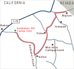
I start riding up Kelbaker Road from where I left off yesterday, intending to turn off at Aiken Mine Road (nine miles away) and
cross a scenic lava field and joshua-tree forest. The Rainy Day Mine turn-off that I was aiming for last night should be along this stretch somewhere, but I
forget to look for it.
I do find Aiken Mine Road easily enough, however, which is marked by a hand-made sign. It's described as a "maintained dirt road" in
Mojave National Preserve literature. Hmmm... It looks extremely sandy. I turn off and figure that I can go a mile or so, perhaps as far as the junction of the
old Mojave Road. If road conditions don't improve, I can always turn back.
Under the weight of my bike, my tires slip and spin intermittently in the sandy surface. I quickly understand that, if I continue, I
will spend most of the day riding Aiken Mine Road's 20.7 miles before arriving at the coveted blacktop of Cima Road at the other end.
I am not ready for this. I don't have enough water to go until tomorrow without replenishing. There is the possibility of filling up
at a couple of springs along Aiken Mine Road, but there's no guarantee that I'll be able to locate them or that they would even contain water. And there's no
one out here I could ask. I came prepared with a water purifier and iodine tablets in case I end up needing to drink dubious water. Had I not skimped on the
amount of bottled water I brought from Baker last night, camping along Aiken Mine Road tonight just might be possible.
After barely a quarter mile of this road, I decide to play it safe and return to the pavement of Kelbaker Road. Though I'm not
realizing it, this marks a turning point in terms of how I will approach the rest of the trip. I originally envisioned doing a lot of dirt-road riding, but it
looks like I'll be sticking to somewhat better-traveled, easier-to-ride routes from now on.
Nipton is the next sure water source in the area, so it remains today's destination as planned. The Cima post office along the way
sells bottled water, but it will be closed today—Sunday. Choosing to follow the paved route instead of Aiken Mine Road will add about five extra miles to
my trek to Nipton, for a total of about 70 miles today. I try not to think about this because I've never covered 70 miles in a day before, let alone on a
10-ton bicycle.
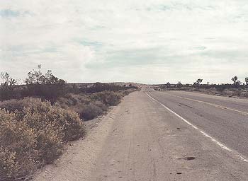 LOOKING SOUTHEAST ON KELBAKER ROAD
Toward summit from near junction of Aiken Mine Road
The next three miles on Kelbaker Road pull me gently to its summit at 3800 feet. The climb is so gradual that I don't feel like I'm
approaching anything in particular. However, the views eastward toward the Providence Mountains are quite delicious and the impending downhill to Kelso looks
far more attractive than I imagined. I'll be coming back up this hill from Kelso later in the week.
A strong wind is pushing against me as I pedal downhill, so I'm not riding quite as fast as I might. 12 miles later at the bottom,
I arrive at Kelso (elevation 2100 feet). Kelso consists of an intersection, a few abandoned small-town buildings, a few modern tract houses, and a gorgeous
boarded-up train station called Kelso Depot. Even in its dilapidated state, Kelso Depot serves as a rest stop. History-information panels, portable toilets and
a pay phone hiding behind the depot lure passers-by. Sorry, no water here.
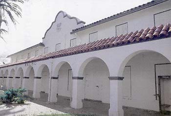 KELSO DEPOT, ABANDONED
Postcard view
I meet a friendly young couple from Virginia (former Californians) who were touring the area, using Las Vegas as home base, and we
chat for a half-hour. They keep offering me water and I drink more than half a litre. Last night, they stayed at the bed and breakfast in Nipton—my
destination today—and really enjoyed the outdoor hot tub, so now I'm looking forward to that little piece of luxury in the middle of nowhere. Before
departing, they refill my water bottle one last time, which I greatly appreciate.
Refreshed, I brave the gradual 19-mile uphill to Cima. As it turns out, Kelso-Cima Road carries slightly more traffic than Kelbaker
Road, at least on this Sunday afternoon. Nothing to be uncomfortable about though. However, with practically no shoulder on this road, I'm finding myself
concentrating more on traffic than on the passing landscape. A gigantic, oncoming, camping vehicle honks its horn and its driver waves heartily. Of course, I'm
more than happy to wave back. This happy event repeats itself several times on this road (and later during the trip too). Almost without my noticing it, the
landscape becomes peppered with joshua trees.
The views of the stark Providence Mountains just to the east are defaced by the slightly raised railway track that runs alongside
the road. The mountains are still clearly visible, but the view of the slowly rising land which attaches them to my roadscape is missing. I like railways, but
I was hoping for an unimpeded view. Minor details like this can take on magnified importance for an uphill-pedaling cyclist!
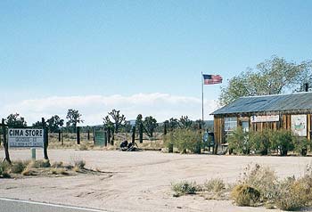 THE STORE AT CIMA, CALIFORNIA
Open until 1:30 p.m.
There's something so satisfying about reaching the top of a hill. The village here at 4200 feet is called Cima ("summit" en
español) and it looks like a tiny farming settlement. It is a quaint and derelict collection of almost shed-like buildings, one of which houses a post
office and a small general store that closes early at 1:30 p.m. I call my mother from the lonely phone booth there to tell her that everything is going very
well (mothers worry about their sons who go bike touring in the desert).
Ready to begin the last leg of today's trip, I start my descent down Morning Star Mine Road into Ivanpah Valley, toward Nipton.
Yippie! Morning Star Mine Road's 15 downhill miles are a little steeper than expected and I glide down at 20-28 mph most of the way.
At the bottom, I ride three flat miles on paved Ivanpah Road to reach Nipton Road, another two-lane paved road. The sun is serious
about setting now and the mountains behind me are extinguishing any residual sunlight. I begrudgingly pull over on the side of the road to mount my lights for
the last seven miles into Nipton. I pedal onward across the valley on the ever-so-gentle uphill, toward those few lights over in the distance, using whatever
little bit of energy remains in me. There isn't much!
I arrive at tiny Nipton at 5:30 p.m., just in time to check in for my tenting space and to buy a few
supplies at the general store (which closes at 6 p.m.)—juice, tea, a can of soup and a couple of bottles of Corona. I'm feeling pretty good about today's
68.5 miles, the longest bike ride I've ever done.
The folks working here have made me feel at home. There's practically no one here tonight, so I was given the go-ahead to set up my
tent in one of the RV spaces. Nipton has a certain quaintness, but it's not at all prissy, and a visit to the community laundry room will remind you that this
is indeed a dusty desert settlement. In addition to the four-room adobe bed and breakfast, there are a few RV hook-ups and tent spaces, as well as a couple of
big tent cabins, all just plunked down on a chunk of desert by the train tracks. The outdoor, under-the-stars hot tub is truly deluxe. Showers (hurray!) are in
a quonset hut frame covered with sheets of corrugated, semi-transparent, green fiberglass. The floor of this "building" is just desert sand, with a small
wooden platform placed in front of each shower stall to prevent wet feet from getting dirty. The arrangement works just fine, though it may sound a little
crude.
I cook myself a quick supper and relax a little before falling into another blissful sleep.