 DISTANCE: 69.9 miles
AVERAGE SPEED: 13.6 mph
ELEVATION: 5600 feet to 984 feet
Morning again, and this time I'm awake early and ready to go, both physically and mentally. I'm excited about venturing into new
territory again, though I really like it up here at Mid Hills. Today, my reward is that all routes are downhill. Warmer temperatures will greet me when I land
at the lower elevations. It's 38°F (4°C) this morning—not the warmest weather for camping. Still, the sun is shining brightly and it's a beautiful
day.
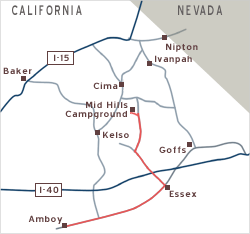
While planning this trip, I left my itinerary unresolved after Mid Hills because several possibilities seemed worthwhile. Last
night, I finally chose one and decided that today I would ride to Amboy on old Route 66.
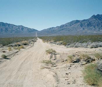
 BLACK CANYON ROAD, LEAVING HOLE-IN-THE-WALL CAMPGROUND
It doesn't look downhill... but it is!
I begin my 15-mile cruise away from Mid Hills and down Black Canyon Road. An unexpected sense of satisfaction enshrouds me when I
realize how much I'm enjoying the dusty drop to Hole in the Wall (which I ascended yesterday). It seems I'm acclimated to rough and sandy roads! Only a couple
of cars pass me along the way to Hole in the Wall.
As I pass Hole in the Wall, the real luxury begins. The final 1500 feet of downhill on Black Canyon Road is paved and in great
condition! A couple more cars pass me. Descending this road in its entirety offers snapshots of the different desert landscapes to be found in the Mojave
National Preserve. The juniper and pinion pine woodlands of the highlands metamorphose into joshua-tree-dotted midlands, and finally give way to the scrubby
brush of the desert floor. This effortless ride starts a day perfectly—the ultimate in tourism. Best of all, the road never plunges steeply, so I'm not
getting tired hands from too much brake-squeezing!
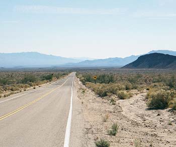
 PIPELINE ROAD OVER FOSHAY PASS, PROVIDENCE MOUNTAINS, CALIFORNIA
No services on this road!
The road ends at the junction of Essex Road, another occasion for a water-and-photo break. I study the awesome westward view of the
jagged, brown Providence Mountains. From where I'm standing, a pipeline service road climbs up to the ridge at Foshay Pass and drops down the other side to the
Kelso Dunes area. I bet that would be a spectacular ride, but it appears steeper than the roads I've traveled here so far. To the east of me, a sandy powerline
road rolls out endlessly across the desert floor toward Goffs, some 20 miles away.
Break time is over, so I turn my back on the magnetic mountain vista and head down Essex Road, a two-lane paved highway. This is
technically a slight downhill, but it feels pretty flat. With little variety in the scrub-brush landscape and only the occasional passing car, the ride across
the desert floor goes mechanically and contemplatively. In no time it seems, I reach the back of a "Welcome to Mojave National Preserve" sign. Funny that I'm
not seeing a sign indicating my exit from the Preserve...
 ESSEX ROAD CROSSES INTERSTATE 40
Looking east at the tube of civilzation
Just beyond, I pause on the bridge over Interstate 40, suspended in mid-air above fast-moving freeway traffic. An unlikely spot to
take a break perhaps, but the oddness of this intense tube of civilization passing through the middle of nowhere feeds my imagination while I refresh with
water and handfuls of trail mix.
Six miles until Essex. Onward I go across more desert-scrub expanse. This stretch is punctuated only by a small, forlorn trailer
park with a hand-painted sign exclaiming "This Is It." A strange sight, on-stage all by itself way out here.
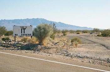 "THIS IS IT" RV PARKING, ESSEX ROAD, CALIFORNIA
At a glance, it's not apparent if people live here or if it's just a storage yard for
vehicles
Arrive Essex, at the junction of old Route 66. As a destination, it offers little. Other than an itty-bitty post-office building, I
see no sign of commercial services. A (recently?) closed gas station/store next door awaits a new life. Out front remains a phone booth that looks operational.
Essex has a utilitarian, abandoned aura that perhaps qualifies it as charming in a Route-66 sort of way. Not pretty, but charming enough for me to loiter here
for a water-and-dried-apricot break. I witnessed someone pull up in a white pick-up truck and use the postal facilities during my break.
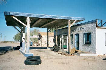 ABANDONED CAFE AT ESSEX, CALIFORNIA
The telephone booth is still operational
This highway, old Route 66, was once the main route across the western USA. It's hard to imagine, really. From here, the next
services are 30 miles west in Amboy (a gas station and café, but no store), or five miles northeast at Fenner. More services exist at Goffs, ten miles
beyond Fenner.
From here, I must head east or west, so this is my last chance to change my plans and opt for Goffs over Amboy. Somewhat
reluctantly, I stick with last night's plan to visit Amboy. The Amboy route will produce less route duplication during my trip. I'm never a big fan of
backtracking, even on shorter trips back home. Also, I'd like to add some variety to my trip by passing through some areas not encompassed by the Mojave
National Preserve.
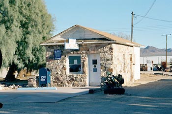 POST OFFICE, ESSEX, CALIFORNIA
A tiny building with a real postal employee with a wealth of knowledge about the area
The first 10 miles or so of westbound Route 66 are proving to be uneventful. The road is
quite straight and flat and I've been spoiled by my super-scenic ride earlier down Black Canyon
Road. A notable headwind is making me work hard just to maintain 10 mph. The scenery isn't inspiring
me much because I can barely see it—the warm sun is shining harshly in my face. Just a
few miles to the north, the stark Clipper
Mountains, with their brown, rocky texture, parallels the road. To the south lies a vast
empty land, with more intriguing, but uninviting, brown mountains (the Old
Woman Mountains) off in the distance.
There is more traffic on old Route 66 than I had expected. Not heavy traffic by any means,
but the speed of passing vehicles defines this as a highway, not as a peaceful, desolate road.
The necessity to pay attention to cars is almost shocking after the relative solitude of my
past few days.
I'm grateful that the shoulder here is paved and in really good shape (except at the frequent bridges over washes, where it
disappears temporarily). It's like having my very own bike lane! I'm starting to enjoy the slow passing of the Clipper Mountains to the north. I'm entering
that meditative, pedal-forever state-of-mind again.
After encountering a couple of small ups and downs, I can make out a longer, grander rise in the road ahead. I'm all excited and
don't seem to be reaching it quickly enough.
It turns out to be a nice, relaxing climb, nothing steep. At the top (Cadiz Summit), I stop for another water-and-dried-apricot
break and inspect the remains of a couple of buildings, vestiges of a past attempt at civilization at this locale. I can see a delicious downhill to the
flatlands on the other side. This big lump of earth I'm standing on is my favorite part of Route 66 so far.
Zoom... Down the hill and a few miles further, I find myself passing through a settlement called Chambless, which has a defunct
market as its centre. I remember reading that there is a camping-RV park here, but I don't see it, maybe because my eyes are fixed on the shut-down market and
the nearby abandoned Roadrunner Café. Also, I'm thinking about food now and I longingly wish that the closed market with its "Mexican food" sign were
still serving up spicy edibles with the beans and rice that are my usual staples. There is a café at Amboy, about 10 miles away, and it's all I can
think about. It will of course still be open around 4:30 when I get there, won't it?
I keep pedaling, Chambless is gone, and I rise over two more mini-summits. I've already forgotten
about the phantom RV-camping park I was going to look for back at Chambless, and I vaguely remember
passing a view of the Cadiz
Dunes somewhere back there. Distance is abstract right now: I'm on autopilot.
I pass the junction of Kelbaker Road, the last, major checkpoint before Amboy. Five miles to go. I say "bye-bye" to that personal
bike lane that has been so graciously escorting me along old Route 66. Actually, I still have a shoulder to ride on, but it's now striped with upheaved,
horizontal fissures which create rhythmic, annoying bumps. There's just enough fast-moving traffic that I can't ride in the traffic lane. My mind is fixated
enough on my destination that I'm succeeded in ignoring the discomfort. As I ride over another hill, the handful of buildings called Amboy crops up. Most
distinguishable is the café and gas station complex. As I get close, I see that the sign also says "motel."
It's 4:35 p.m. and dusk is just starting to close in. I pull into the gas station and notice a cardboard sign in the café
window that says "closed." Inside, an employee is moving about and, at the counter, four men are eating. I try the glass door anyway in case the sign is in
error, but in vain. Cued to the rattling of the door, all four café patrons simultaneously turn their heads to see me outside the door looking in. The
four heads then rotate back toward their respective plates. I'm the stranger who comes into town in one of those western movies.
Indecisive, I linger outside, not sure what to do or where to go. A lone fluourescent tube casts a sickly light on the gas pumps.
I've easily accepted the disappointment of not having a hot meal in the next few minutes, but I haven't given much thought to tonight's sleeping arrangements.
The idea of a room appeals to me and the old sign out front does say "motel."
I have about 30 minutes until complete darkness. My headlight battery hasn't been recharged since it burned out on Cedar Canyon Road
two nights ago, so night riding is not an option. To pass a few minutes and hopefully arrive at a decision, I say hello to the pay phone and call a friend at
work to leave a voice-mail message to tell her where I am and that all is OK.
I can't just stand here forever... I try to get the attention of the employee inside the cafe to find out where to ask about getting
a room for the night. He sees me from behind the counter, but doesn't approach the door. Instead he shouts loudly enough for me to hear him, "I'm closed,
you understand?" Angrily, he adds "You go!" and forcefully points the direction I should use to leave.
Through the glass, I hope he can hear my "I know, but do you know where I can ask about getting a room?" He blurts out a nasty, "I
don't know" and walks back to the kitchen. Is he always like this or is he just having a bad day? Do would-be customers always arrive at closing and drive him
crazy? Come to think of it, now I really do want to leave, but first I should decide where to go.
I take a brief walk around the complex of gas station, cafe and motel. I see nobody. Are these motel units even used? Well, there
are a couple of parked cars... For a moment, I consider simply setting up my tent up a few hundred feet down the road, but I realize that I'd probably be smart
to vanish from this hostile outpost.
Something is amiss here. The outdoor pop machines live inside a bomb-proof iron cage that barely allows one to insert money or
retrieve a purchase. Most of the motel cabins and the concrete-block "public" washroom building lurk behind a curtain of tall chain-link fencing. And that
hostile café worker... Why does this stop on the highway give off some of the aura of an inner-city ghetto?
It's nearly dark now. Hastily, I get back on my bike and head east on Route 66, back the way I came. Where am I going? Anywhere.
Half a mile passes and I turn down a set of tire tracks that lead out into the shrub-dotted desert, just because it's there. Where am I going? I'm almost
there. I am scanning for a prospective campsite amidst the small piles of rusty metal cans and broken glass that sporadically litter this landscape. Finally,
the dump is thinning out. Although I am disturbed by the unsightly surroundings, I'm most concerned with being invisible from Amboy and passing highway
traffic.
None of the bushes here would provide a lot of privacy, but one does look a little more voluminous than the others. I hastily pop up
my tent, just in time for total darkness. I set my mental clock to wake up as early as possible so I can leave at the first sign of sunlight tomorrow
morning.
Gingerly, I unpack as few items as possible so that my morning departure will be as quick and simple as possible. I find myself
getting obsessive; I've never been so disciplined about how I unpack. To further simplify matters, I've decided not to cook a meal. I pull out those cans of
sardines.
The occasional traffic on the highway a quarter-mile away is quite audible in this otherwise silent landscape. Such signs of human
presence soothed me while tenting just off Kelbaker Road, but not here exposed in an imaginary inner-city ghetto. I turn out my flashlight lantern for a few
minutes, wondering if passing cars could notice a unexplainable blit of light out here in the dark expanse.
I turn the lantern back on, but put the light end face-down on the tent floor to obtain the least light possible. I peacefully eat
three tins of sardines (yummy!) and put the fourth one aside. I also finish off my open bag of turkey jerky. Just as I start writing notes in my journal, I
hear a car on the highway pull over. Doors open and close a few times. Someone pissing on the side of the road I guess... But it seems to be taking a rather
long time. Doors open and close a few more times, but there are no voices. Finally the car pulls away and I laugh at myself for being so paranoid.
Half an hour has passed and I'm hearing another car pull over. A popular spot it seems... "Why there?" I wonder. Coincidence? Again,
doors open and close a few times. No voices. Through the quiet of the desert night, I can clearly hear a person's footsteps. They stop. Hopefully, they won't
start coming my way. More silence. Good. Someone coughs once and it sounds remarkably close even though I know it isn't. After five or ten minutes of suspense,
car doors open and close again and then the car leaves. Why so much door-opening if there's only one person? Or if there's more than one person, why isn't
anyone talking?
I lay down desperately and the minutes stretch out like hours. I know I need to laugh at myself again for being so paranoid, but my
sense of humour—and the rest of me—is tired. At 69.9 miles, today's ride was my longest ever. It was a great ride, but the finale is a little weird.
I still have a few hours until midnight, but I'm wondering if I'll ever attain the ecstasy of sleep tonight. I turn off the lantern and try.